Overview of the steps: Make up the map, compile an edge type file, and generate the SUMO network file.
OpenStreetMap is a valuable source for real-world map data. This tutorial shows you
- how to prepare a map of OpenStreetMap to be useful for traffic simulation and
- how to import this map to SUMO.
You may also find the following pages useful:
- Tutorials/OSMWebWizard
- Networks/Import/OpenStreetMap
- Tutorials/PT_from_OpenStreetMap
- OpenStreetMap file
- Networks/Import/OpenStreetMapDownload.
Prepare the Map of OpenStreetMap#

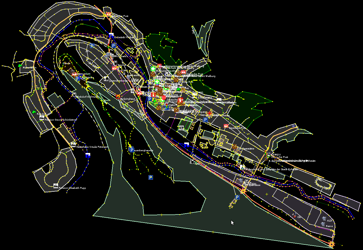
The OpenStreetMap file is created in this step. The picture shows the German city Eichstätt opened in JOSM.
The first step in this tutorial is to obtain a map the vehicles can drive in. If you do not want to perform this step, you can take Tutorials/OSMActivityGen/eichstaett.osm. It has been prepared with this tutorial.
To get a detail out of OpenStreetMap, you can either use the export function of the web site or the program JOSM. Both can save a selection of objects (usually given as a rectangular range) into a file: the OpenStreetMap file. You can simply use this file as the map for your traffic simulation with SUMO.
The data in OpenStreetMap is often not completely ready for traffic simulation though. For a good simulation, the map must usually be enhanced. The following steps are recommended for the same:
- Complete the map directly in OpenStreetMap. Follow the guidelines on
the OpenStreetMap wiki in the area
Map Making. They give valuable hints what software to use and how
to encode all attributes of the map. You should ensure that the map
contains all data related to traffic simulation. (At this stage,
fill in only correct data that can be well understood by others. Do
not tweak the map just for your simulation - that comes below.)
For the given example of the city Eichstätt, I found that most
streets were already in the map – they were sufficient for my
simulation. So I only looked at the tags (description of
properties) of the streets in OpenStreetMap and did not add new
streets. I took a notebook with the OpenStreetMap editor JOSM, drove
through the city and corrected the following attributes:
- The type (importance) of a street is defined with the tag highway. This attribute helps SUMO to determine the implicit speed limit and right of way rule.
- All streets with speed limits that differ from the implicit regulatory limits (i.e. speed limits set by traffic signs) should have a tag maxspeed. The correct speed limits help SUMO to find reasonable routes through the road network.
- One-way streets often have a significant impact on the traffic flow. They can be marked in OpenStreetMap with the key-value pair oneway=yes.
- The correct number of lanes helps to avoid unrealistic traffic congestions in the simulation. The tag lanes specifies the total number of lanes of a street, for both directions together. So you cannot describe various complex lane configurations in OpenStreetMap (like two lanes in one direction, another lane for turning right and one lane for the opposite direction). They can only be defined in the SUMO network file directly or its corresponding SUMO XML description files. Such lane configurations go beyond this tutorial.
- In OpenStreetMap, traffic lights are nodes marked with the key-value pair highway=traffic_signals. Each traffic light is independent; you cannot associate several interdependent traffic lights at a big junction with each other. Again the SUMO network file can contain such a complex logic and netconvert tries to detect such interdependent traffic lights when you use the option --try-join-tls (see section #Convert the Map in the SUMO Net Format below).
- Finally go through the warnings of JOSM. Most of them do not affect your work, but some of them help you to find significant errors in the map (like unconnected streets). During this step, do regularly upload your modifications to OpenStreetMap to avoid conflicts with the modifications of other editors.
- Now the map in OpenStreetMap should have the necessary quality for your simulation. Next, you should determine the desired detail of the map and export it in an OpenStreetMap file. Be careful to never upload the map back to OpenStreetMap from now on.
- Finally you can enhance the map for your specific purpose: Open the OpenStreetMap file in JOSM. Find the right nodes at which streets should end and remove unnecessary objects (which are out of the desired detail). The section Networks/Import/OpenStreetMap#Editing OSM networks describes further ways to clean up the OSM file. But actually, most clean up is done by netconvert anyway (see section #Convert the Map in the SUMO Net Format below). You are able to tweak the map for your purpose, for example, by adding or removing roads, changing their type, and so on.
Now you have a good map for your simulation in an OpenStreetMap file. The image on the top shows the map of the city Eichstätt, which I have prepared for traffic simulation. You can download the map (eichstaett.osm) to follow this tutorial.
While the OpenStreetMap format is a widely spread format to describe a map, SUMO has its own format for this: the SUMO network format. As a consequence, you must first convert the OpenStreetMap file in a SUMO network file. The next two steps guide you through the conversion process.
Configure Implicit Attributes of the Map#
In a OpenStreetMap file, the highway attribute implicitly determines values of some other attributes, like the speed limit. You must tell SUMO these implicit values in the SUMO edge type file. It assigns default values to the road attributes speed limit, number of lanes, priority, one-way street and allowed vehicle classes depending on the highway type. The article SUMO edge type file provides several pre-defined SUMO edge type files and explains how you can compile your own edge type file.
In this step of the tutorial, determine the implicit values of every highway type defined by the OpenStreetMap community. Several edge-type files suitable for OpenStreetMap are included with SUMO, some of them are meant to be combined.
For this tutorial, the type files <SUMO_HOME>/data/typemap/osmNetconvert.typ.xml and <SUMO_HOME>/data/typemap/osmNetconvertUrbanDe.typ.xml were used. Please make a copy to your local directory if you want to modify them.
Convert the Map in a SUMO Network#
You can now create a SUMO network file. The minimum options are the OSM file and the name of the output file. Further options are recommended when importing OSM data into SUMO:
    netconvert --xml-type-files osmNetconvert.typ.xml,osmNetconvertUrbanDe.typ.xml \
     --osm-files eichstaett.osm --output-file eichstaett.net.xml \
     --geometry.remove --roundabouts.guess --ramps.guess \
     --junctions.join --tls.guess-signals --tls.discard-simple --tls.join
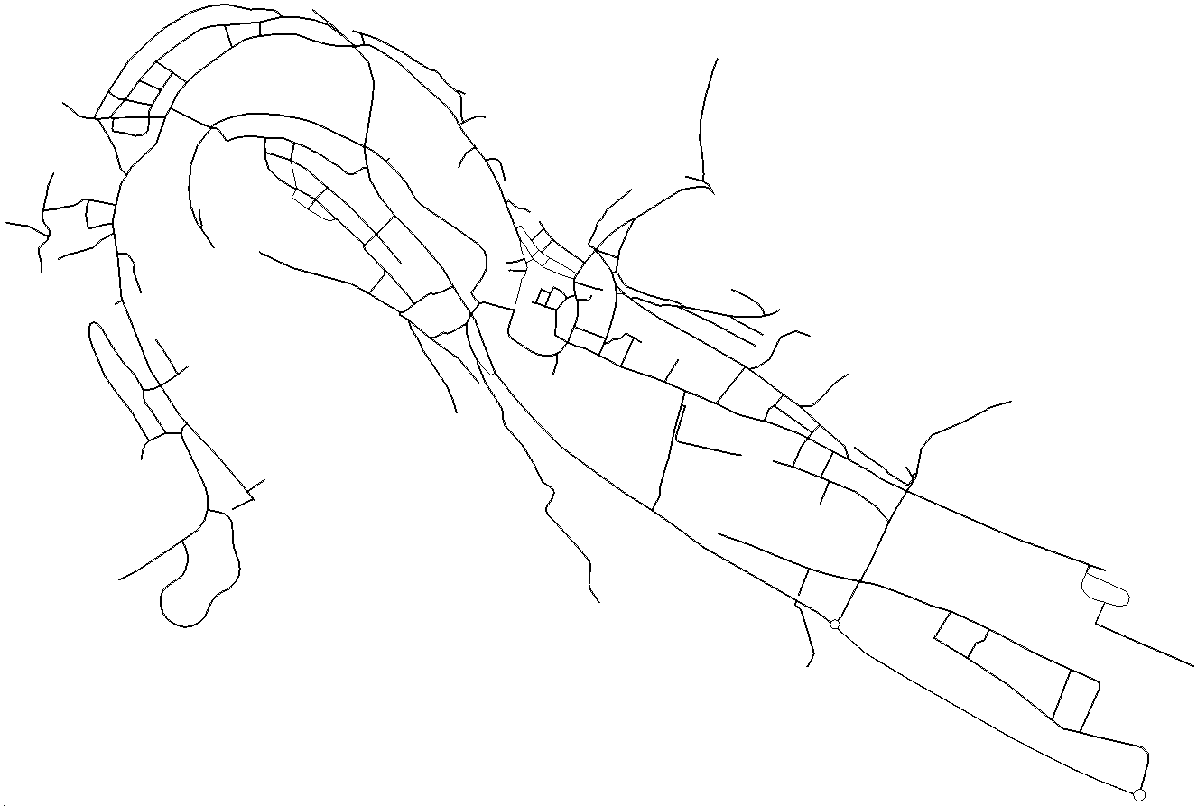
netconvert extracts the simulation-related information from the OpenStreetMap file (see the image of Tutorials/OSMActivityGen/eichstaett.osm above) and puts it out in the SUMO network file (see the image of Tutorials/OSMActivityGen/eichstaett.net.xml below). During this process, it adds some assumptions about the traffic lights and the connections between lanes at junctions. You can read further information on this process in netconvert, Networks/Import/OpenStreetMap and SUMO Road Networks.

The map stored in the file eichstaett.net.xml. In this map, SUMO runs its simulation. Compare it with its source, the OpenStreetMap file shown in the image above.
Further options of netconvert can be very useful for the OpenStreetMap import:
-
--remove-edges.by-vclass / --keep-edges.by-vclass
In the SUMO edge type file, you could discard roads of a certain type. In addition, SUMO can discard roads that are restricted to certain vehicle classes. These classes are given with this option. In SUMO edge type file you can find a list of SUMO vehicle classes. Reducing unnecessary roads makes (i.e. footpaths) makes it easier to work with the network. To obtain a network for simulation of passenger traffic only, the option --keep-edges.by-vclass passenger can be used.
-
--keep-edges.components
Keeps only the <INT> largest connected components of the network (Usually only 1 is desired). Warning: This could remove railroads or other edges you would like to keep. So check the messages of netconvert.
-
--verbose
Prints additional output.
Now read the messages netconvert printed out very carefully. Try to
understand the warnings, if any - they can give you hints about how your OpenStreetMap
file could be improved to make it suitable for conversion. Get back to
your OpenStreetMap file in JOSM to fix errors or tweak the map for
conversion. I found, for example, unconnected roads with this process. I
also moved some junctions slightly, because netconvert had problems if
two junctions are very close together. But finally, I managed to convert
the OpenStreetMap file without any warnings in a SUMO network file.
(Certainly the OpenStreetMap file eichstaett.osm I provided above is
already the improved version.)
Congratulations! When you performed all the steps so far, you have a
map suitable for traffic simulation with SUMO. It is in the SUMO
network format. The map of the
tutorial's example is in the file
Tutorials/OSMActivityGen/eichstaett.net.xml.
Above on the right, you see an image that visualizes the file. I opened
eichstaett.net.xml with the program sumo-gui and took a screenshot.
When you look back at the work you have done so far, most of it was necessary to polish the OpenStreetMap data for traffic simulation and to add missing information. A good map is hard to obtain but very important for traffic simulation.


